Welcome home beached bird COASSTers! On this page you will find data sheets, training videos, and answers to our most frequently asked questions about your surveys. If you’d like to join COASST beached bird surveys, please visit the Join Our Team page to read more about our program.
Data Sheets
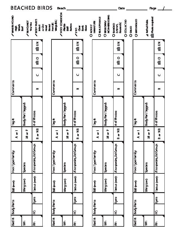
The latest versions of the COASST data sheets can be found below. You should complete a copy of the Cover Sheet after each survey, but you only need to fill out a Beached Bird Data Sheet if you find birds. Click to download a pdf.
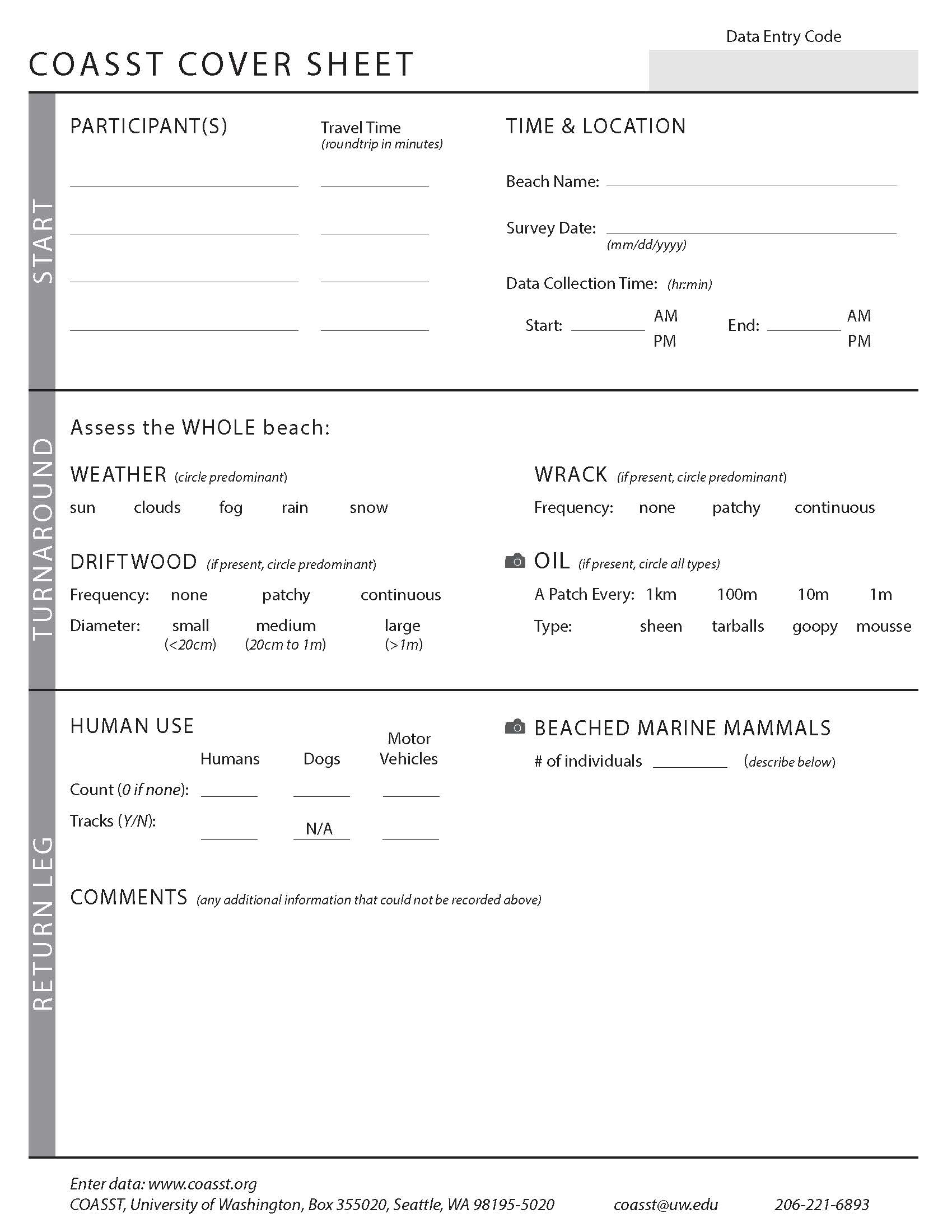
COASST Cover Sheet
This 2-pager is a COASST Cover Sheet with a Beached Bird Data Sheet on the back.
Training Videos
From Head to Toe
Want to brush up on your beached bird measurement skills? Here’s a video providing an overview of the bill, wing chord, and tarsus measurements.Digital Deep Dives: refresher recordings
Intactness
In this webinar we discuss the Body Parts section of the data sheet. What makes a bird intact, and can you count a body part that isn’t measurable? Plus measurement demonstrations for bird wings and feet!Invasive Green Crab
Crab Team’s Emily Grason shares the story of the green crab invasion on the West Coast, and helps COASSTers learn to identify and report molts and crabs on their surveys (links in the FAQ section below!)Oil Spill Stories
What can COASST learn about oil spills and seabirds? That’s one of the questions that got COASST started in the first place! Data analyst Tim Jones shares his work.Wreck Protocol
In this video we discuss streamlined data collection protocols for beached birders in seasonal wreck events and mass mortality wreck events. Photos are king!Plumage Identification
In this video we dive into the advanced identification topics of plumage variation: male vs female, adult vs immature, and breeding vs non-breeding birds.Data entry for Beached Birders
In this video we discuss tips and tricks for entering your data online, viewing changes as birds are verified, and exploring data on the COASST website. Please note that you can now leave the section asking for Zone Widths blank! This was a change that occurred in 2025, but the video has not been updated.Marine mammal reporting
In this video we discuss the reporting of marine mammals, on and off COASST beached bird surveys. Our participants can find stranding network numbers at this address: https://www.fisheries.noaa.gov/report and more identification resources at this address: https://mmapl.ucsc.edu/resources.Foot Key ID and Tags Demo
In this session we cover the trickiest parts of the foot key, including fourth toe shapes and provide a demo on using the new tagging system!Western Snowy Plovers
In this session we talk about identification, natural history and conservation of Western snowy plovers, as well as considerations for surveys on beaches where they breed.Feather Molt
This video explains the role of feather molt in bird natural history, and how and why data verifier Charlie Wright distinguishes between adults, immatures and molting murres.Feather Molt: Alaska Edition
This video explains the role of feather molt in bird natural history, and how and why data verifier Charlie Wright distinguishes between adults, immatures and molting large Alcids.West Coast Wing Key Demo
This video demonstrates how to use the west coast edition of Beached Birds: A Field Guide to identify a beached bird with only a wing.Alaska Wing Key Demo
This video demonstrates how to use the Alaska edition of Beached Birds: A Field Guide to identify a beached bird with only a wing.FAQs
If multiple zones appear to be present in equal levels, follow the following hierarchy:
When wrack and surf are present, call it wrack.
When wood and wrack are present, call it wood.
If vegetation and any other zone are present together, call that zone vegetation.
Like most other things in COASST, think in terms of predominance. The vegetation zone begins when vegetation becomes a consistent on the section of beach that you are measuring. A few sparse plants don’t count. An odd log or two does not constitute a wood “zone”, but an area where many logs have accumulated does.
Wrack is (almost) all of the floating material deposited by the tide. Obviously most of the wood on a beach came in on the tide at some point, usually during storms where big waves have “thrown” the wood high up on the beach, which would include material that makes up the wood zone.
Think of the wrack as the material that has been deposited on successive days of the tidal cycle. It is all of the small stuff (i.e. seaweed, shells, Velella velella, and marine debris) that could easily be washed away and re-deposited in the next days of the tide washing in and out.
Wrack may include some wood pieces, but it is less likely that a continuous line of large logs washes in and out daily on the tide. That more permanent line of wood would be defined as the wood zone.
A live marine mammal doesn’t need to be recorded on your COASST Cover Sheet (except in the comments section of course!)
Depending on your location, there are different marine mammal stranding networks who will respond to a live marine mammal in distress.
Before you survey, check NOAA’s reporting website to find the number of your local stranding network to carry with you on your survey.
If you can only fit one number in your phone, choose this one: the NOAA West Coast Stranding Hotline 1-866-767-6114. These folks will redirect you and your information to the local network.
Each stretch of coastline has its own local marine mammal stranding network that either records reports for a national database or responds to individual calls to collect additional data.
Before you head out to the beach, take a look at these links to find your local beached marine mammal network number. If you can call from the beach and give explicit directions to the location of the carcass, the stranding networks are often able to follow up and collect additional information after you head home.
West Coast Marine Mammal Stranding Networks
Alaska Marine Mammal Stranding Networks
Please also record each beached marine mammal on the COASST cover sheet. When you submit photos along with your description, it helps the experts in the office make an identification!
If you can only fit one number in your phone, choose this one: the NOAA West Coast Stranding Hotline 1-866-767-6114. These folks will redirect you and your information to the local network.
If there is a hazardous spill on your beach please call the US Coast Guard’s National Response Center at 1-800-424-8802 (toll free from the USA) or 1 (202) 267-2675 (direct dial). Reports can also be made online at www.nrc.uscg.mil.
There are numerous wildlife rehabilitation agencies across the coast. Depending on where you live, you’ll get in contact with a different local agency. Here are a few pages with directories where you can locate a local organization:
Here’s a reminder about some of the key ID features, from our partners at WSG Crab Team.
As for reporting, it depends on where you survey!
ALWAYS write a note about your discovery in the comments section of your cover sheet, and take a picture with your scale ruler so we can help confirm the species. In addition:
If you live in Alaska, green crab reports can help pinpoint the ‘invasion front’.
- call 1-877-INVASIV
- or to use the Alaska Dept of Fish and Game online reporter
- in Kenai you can also visit Kenai Invasives
If you live in Washington, reports can trigger immediate response by WSG Crab Team. Leave all crabs in place, but a molt (just the shell!) can be collected to help confirm ID.
- if you survey inside waters, report your crab finding to Crab Team’s Reporting Page
- if you survey the outer coast, let the COASST office know about your findings
If you live in Oregon or California, the green crab invasion is well established. Harvesting crabs themselves is also legal. You can learn more at the following links:
- Oregon: The Seadrift Green Crab Project
- California: South Slough NERR (2020 Green Crab report)